1. To turn on the Horizontal Grid system:a. Click on the Horizontal Grid button, located in the bottom left-hand corner of the screen, to toggle On the grid.
Note: Clicking on this toggle again will turn the grid OFF.OR b.Go to the Parameters menu, under Coordinate Grids, and select Equatorial Grid.
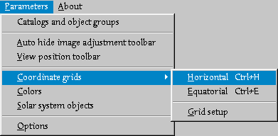
2. To control the setup of the grid - that is, the separation between grid lines and whether or not both the altitude and azimuth lines are displayed or not:a. Go to the Parameters menu, under Coordinate Grids, and select Grid Setup.
You'll get a pop-up box that looks like this:
Note: There should be a check-mark in the box, if the default settings are active. If they have already been turned off, clicking the box again will turn them back on.c. To toggle on and off the altitude and azimuth lines, click those boxes. If they're on, a check-mark will be present. If they're off, there will be an empty box.
Note: The step for both the azimuth and altitude lines are in minutes (deg:min:sec).
 Kara's
Homepage
Kara's
Homepage

