We've seen that Star Calc 5.0 uses two very different coordinate systems - Equatorial Coordinates and Horizontal Coordinates. But although it is easy to see that these two coordinate systems appear very different, pinning down what exactly why the two systems exist and why we use both is much less apparent.
Let's take a look at screen shots of each coordinate system:
Equatorial Coordinate Grid
Horizontal Coordinate Grid
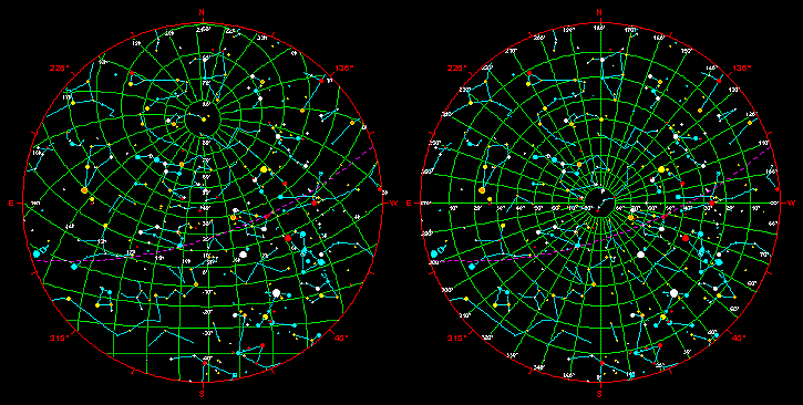
The most obvious difference is, of course, their center points. While the center of the grid for the horizontal system appears to be in the center of the sky, the center for the equatorial system is somewhere up towards the north, definitely off-center.
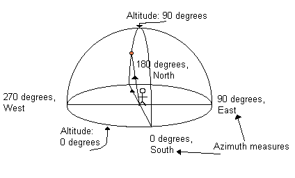
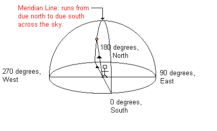
The reason for this is simple. The horizontal system, which has coordinates of azimuth (angular measurements around the map, with South = 0 degrees, North=180 degrees) and altitude (the horizon = 0 degrees, and straight overhead=90 degrees, hence the name horizontal coordinates) is centered on your view of the sky. For instance, the star in the picture below has the approximate coordinates 180 degrees (due North) by 40 degrees in altitude. (This describes Polaris, the North Star, as viewed from State College's latitude.)
Throughout the night, different stars cross through the coordinate system (for a movie of the stars moving across a horizontal coordinate grid, click here). That means that though a star may be located at a certain azimuth and altitude at a certain time, that measurement is only valid for that particular time and place (for most stars - we'll get to that in a minute). You can see how that could be kind of inconvenient for astronomers who were trying to correlate things they had seen with things that astronomers in other cities and countries had seen. You would be constantly changing your coordinates back and forth!
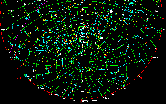
The Equatorial system solves this problem. As we observed earlier, the equatorial system is centered somewhere up to the north of the sky. Actually, it is centered on the North star, Polaris. Polaris (and the stars within a few degrees of Polaris on the sky) never rises or sets. Check in StarCalc if you're not convinced. The sky rotates around Polaris all night (and all day, too, except of course we can't see it then). Polaris is visible from anywhere in the Northern hemisphere. The Southern hemisphere also has a pole star, called Polaris Australis. Polaris Australis isn't nearly as bright as Polaris, nor is it quite at the Southern equatorial pole, but it is there and is visible to the naked eye.
The Southern Equatorial Pole and Polaris
Australis
The equatorial coordinate system is a fixed coordinate system, meaning the coordinates that describe the location of a star don't change with location on the Earth or with time. Instead, what changes is the area of the coordinate system visible at any given time or place.
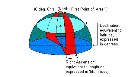
Imagine a normal globe, a spherical map of the Earth sitting on your desk. You can see on it latitude and longitude lines, circling that globe, cutting the continents into pieces and allowing cartographers to assign every tiny parcel of land a specific latitude and longitude, which will never change. Well, with equatorial coordinates, astronomers have done the same thing to the sky. Latitude, in this case, is called declination(d) in StarCalc and most astronomy references), and like latitude, is defined to be zero at the Equator (hence Equatorial coordinates). The equivalent of longitude is right ascension (a) in StarCalc and most astronomy references). The zero point of a is a bit harder to conceptualize, but is defined as zero where the constellation Aries crosses the ecliptic plane on the Vernal Equinox.
The graphic above shows (for simplicity of drawing) the declination and right ascension as viewed from the North Pole - for State College, or any other city, you would need to tilt the globe illustrated above so that the coordinate (0,0) lines up with the horizontal coordinate (latitude,0) on your sky. If you look at Polaris (the star illustrated above) in StarCalc, you will discover that in horizontal coordinates, it is in fact located at exactly (latitude, 0), or, more accurately, (latitude,<any value>), since it sits at the junction of every right ascension line, the same as the North Pole sits at the junction of every longitude line.
Equatorial coordinates make it much easier for astronomers to tell what star a person is referring to, since all stars have fixed coordinates. Of course, it does make it harder to know whether or not a star will be visible in your area at a particular time. To discover this, we have to invoke a concept called sidereal time, or 'star time', as opposed to solar time (which is the normal clock we use every day).
Sidereal time is, quite simply, the time as determined by looking at the stars. Obviously, this is easier to do at night! Sailors have been navigating by the stars for centuries, even millenium - long before they had any notion of what stars actually were. Without going into great detail about the motions of the celestial sphere (as astronomers refer to it) and how it relates to location on the surface of the Earth, the sidereal time at any given moment is determined by the a that is on the meridian - the middle line, halfway between the horizons - at that time. So, if it is 11 pm and a star sitting on the meridian has an a of 5h35m, the sidereal time is 5:35 am. Similarly, if it is 4 am and the same star is on the meridian, the sidereal time is still 5:35 am. Sidereal time has no relation to local light levels.
Figuring out the sidereal time given the time of year and the solar time, or figuring out the solar time given the time of year and sidereal time, is a little bit more complicated conceptually and mathematically. However, since we have a starmapping program at our disposal, it is relatively easy to figure out what right ascensions will be available at any given time - simply go into the program, set the time and location, and check!
![]()